The Boles at Moyge, county Cork
Back to The Boles of Cork, Richard Boles of Cork or Richard Boles of Cork's Family Tree The Boles of Cork siblings were tenants of Lord Percival's in north Cork as early as 1639. During the Rebellion of 1641 they had to abandon those lands and take refuge in Cork city. Captain Thomas Boles and his brother Richard Boles were instrumental in turning the city over to Cromwell's troops in 1649. Likely as a reward for that support Cromwell granted them some land at Moyge in northern Cork. Pender's Census of 1659 lists Richard Boles and his son Francis as the proprietors of Ballynaltra (Ballinalty) and Kilbreedy (Killabraher) in the Parish of Liscarroll. After the restoration of the monarchy in 1660 many of Cromwell's grants were reversed by Charles II but Richard's land was confirmed to him in 1666: "In the Gt. Plowland of Moyge called
Kilbreedy and in Ballinlawbeg plowland 233a.0r.0p. Also in the same
plowland in Ballinalty and in Ballinlawbeg 63a.1r.0p. Also in Ballinalty
and in Ballinlawbeg 55a.0r.30p. Also in both 55a.0r.30p. In Moyge
aforesaid called West Moyge and Ballinlawbeg 37a.3r.30p. Also more in
the same 40a.1r.0p in the Barony of Orrery and Kilmore, County Cork.
Total quantity 570a.2r.10p Plantation measure 924a.0r.35p Statute
measure. Crown Rent total £8.13.3.” Letters Patent dated 15th
January 18th. Charles II. Enrolled 12th February, 1666
(The land
measures are in acres, roods (4 roods=1 acre) and perches (40 perches=1
rood), example: 55a.0r.30p would be 55 acres 0 rods and 30 perches or
almost 55 1/4 acres. The total areas given add up to 484a 3r 10p
although the total stated in the grant is given as 570a 2r 10p so there
was possibly some other land granted to him not mentioned in this
extract. These are Irish acres, also called Plantation
Acres, which are 1.62 times larger than our current statute acre so his
grant was for about 925 statute acres or about 1.5 sq. miles of land.
The term Plowland means an area of farmland which a team of 8 oxen could
till in one working year, an area which could be tilled by one ox was an
'oxgang' which was typically about 15 acres but varied widely from
region to region and between countries. So a 'plowland' was
typically between 120 and 150 acres. The grant implies that the
farms Richard was granted were all within the Moyge and Ballinlawbeg
plowlands which were likely adjacent to each other. It's
impossibly for 570 acres to lie within two plowlands, even two very
large ones, so much is missing from the above extract which is given
here as quoted in several previous papers which discussed the
reallocation of land in Ireland after Charles II's restoration (ex.
Casey A. E. 1966 O’Kief, Coshe Mang, Slieve Lougher, and Upper
Blackwater in Ireland Vol. XI. Birmingham, Alabama: Knocknagree
Historical Fund; pp. 950).)
"In the Gt. Plowland of Moyge called
Kilbreedy and in Ballinlawbeg plowland 233a.0r.0p. Also in the same
plowland in Ballinalty and in Ballinlawbeg 63a.1r.0p. Also in Ballinalty
and in Ballinlawbeg 55a.0r.30p. Also in both 55a.0r.30p. In Moyge
aforesaid called West Moyge and Ballinlawbeg 37a.3r.30p. Also more in
the same 40a.1r.0p in the Barony of Orrery and Kilmore, County Cork.
Total quantity 570a.2r.10p Plantation measure 924a.0r.35p Statute
measure. Crown Rent total £8.13.3.” Letters Patent dated 15th
January 18th. Charles II. Enrolled 12th February, 1666
(The land
measures are in acres, roods (4 roods=1 acre) and perches (40 perches=1
rood), example: 55a.0r.30p would be 55 acres 0 rods and 30 perches or
almost 55 1/4 acres. The total areas given add up to 484a 3r 10p
although the total stated in the grant is given as 570a 2r 10p so there
was possibly some other land granted to him not mentioned in this
extract. These are Irish acres, also called Plantation
Acres, which are 1.62 times larger than our current statute acre so his
grant was for about 925 statute acres or about 1.5 sq. miles of land.
The term Plowland means an area of farmland which a team of 8 oxen could
till in one working year, an area which could be tilled by one ox was an
'oxgang' which was typically about 15 acres but varied widely from
region to region and between countries. So a 'plowland' was
typically between 120 and 150 acres. The grant implies that the
farms Richard was granted were all within the Moyge and Ballinlawbeg
plowlands which were likely adjacent to each other. It's
impossibly for 570 acres to lie within two plowlands, even two very
large ones, so much is missing from the above extract which is given
here as quoted in several previous papers which discussed the
reallocation of land in Ireland after Charles II's restoration (ex.
Casey A. E. 1966 O’Kief, Coshe Mang, Slieve Lougher, and Upper
Blackwater in Ireland Vol. XI. Birmingham, Alabama: Knocknagree
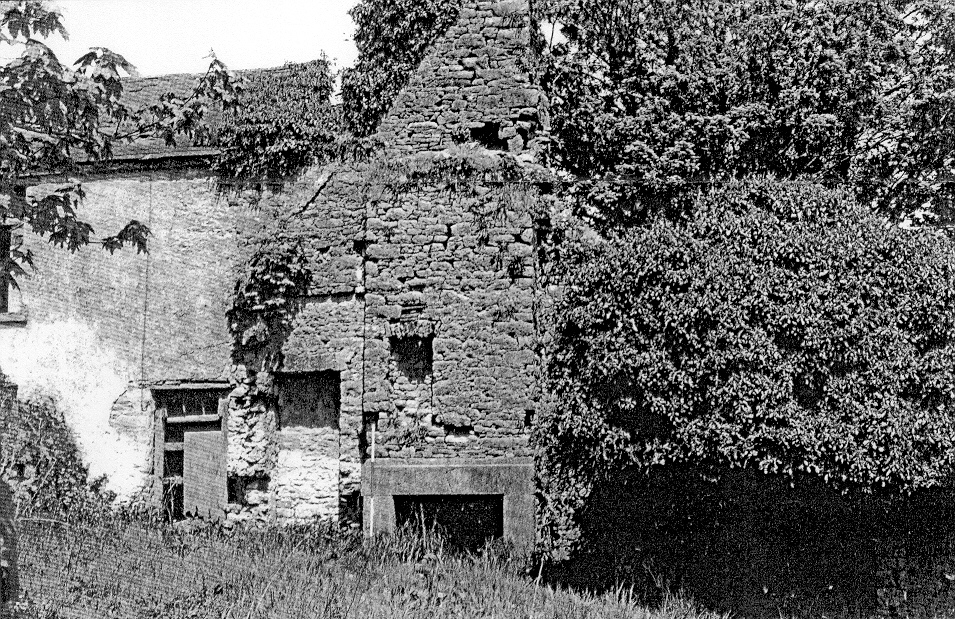
Historical Fund; pp. 950).)Richard's brother Thomas was also granted land at Moyge, however Thomas sold his land allocation to Richard and settled in south Cork as a tenant of Admiral Penn's (William Penn's father). See Thomas Boles of Kilbree Pender's Census also lists a Daniel Crone holding land at Moyge in 1659. We know from other sources that Daniel Crone had married another Boles sibling, their sister Joanne (Joan or Jeane in some references), by 1646 as they baptized a son, Daniel, at Christ Church in Cork city in 1647. The 1685 Will of a third brother, William Boles who settled at Kanturk co. Cork, refers to his 'brother Richard Boles of Ballynalty' and his 'sister Jeane Crone of Moyge'. See The Boles of Cork Family Tree Richard's son Francis predeceased him in 1674 leaving a young son William aged 2 1/2 according to Francis' Will. Richard died in 1693 and was buried in the Boles of Moyge family tomb in Killabraher Cemetery. Young William must have not survived as he would normally have been Richard's heir but it was Richard's second son Thomas who then died three years later in possession of Moyge leaving it to his son Thomas (II) who was about 16 at the time. Thomas II married Catherine Upton in 1703 and is credited for building the Great House at Moyge. The Boles family's own records (ref. Nick Boles of London) state "Thomas Boles of Moyge, afterwards Killybraher, Esquire and JP for Co. Cork and Limerick. Will dated 1749. He built the mansion at Moyge, which place he much improved. When his son married, he got this domain, Mr. Boles going to live at Killybraher. He was an active magistrate, the terror of evil-doers, and a most valuable member of society. He died universally regretted in 1749 (and was buried at the old church in Killybraher where all those of the eldest branch rested) leaving one son and four daughters.” From this point on there is much more specific information about the Boles' properties at Moyge due to the establishment in 1708 of the Land Deeds Office in Dublin where a memorial summary of every land transaction in Ireland had to be registered. From these deed memorials we learn the following about the Boles land at Moyge: (note: the memorial numbers given denote the Memorial Volume, the page in that volume and the memorial # on that page) We find further details about the estate of Thomas I who had died ca. 1695 (his Will received probate in 1696) when his children were still underage to inherit. Thomas II would have been of full age (21) about 1701 and his brother Richard a few years later when they would come into control of their inheritances. Until then it was probably managed by their mother Anne (Warner) and their uncles Jonathan Boles and Thomas Warner acted as overseers of the estate. Thomas II was the principle heir while Richard was left Ballinalty and a half share in the West Quarter of the Moyge plowland. Richard was involved in a sugar refining business in Dublin for a few years in the 1710's. He married in 1717 and was back in Ballinalty in 1720 when he and his wife Catherine Rogers sold off their holdings in the Moige area to Thomas II. Catharine died shortly after and I've found no further record of Richard until his death in 1752.
Ballinalty and the West Quarter of Moyge
The sale in 1720 was a classic Deed of Lease and Release made between Richard and Thomas II. The first deed (memorial 25/466/15595 Registered May 10, 1720) was a lease signed on April 25, 1720 in which Thomas was made the tenant of the town and lands of Ballinalty for 5 shillings and of Richard's half share in the West Quarter of the Plowland of Moyge for one peppercorn, both for 1 year. Those token amounts were formalities which technically met the legal requirments for tenancy but where never meant to actually be paid. Then, the very next day, the same witnesses were called back for the release of the above two holdings and also the grant of some land in neighbouring Ardagh which Richard had on lease from a Bartholomew Falon. This second memorial (26/322/15594 Registered May 11, 1720) gives the sums involved stating that Thomas paid Richard and Catherine sums of 800 pounds, 500 pounds and a further 10 pounds sterling. This process of Leasing to a tenant whom you could then transfer ownership to a day later was a method of avoiding the taxes on outright land grants. The Ardagh land had to be done as a grant as Richard himself was the tenant of that land but he could sell his tenancy agreement for which the landholder (Falon) also signed the second document giving his approval of the change in tenancy. One of the witnesses on both documents and their memorials was Henry Warner of Ballinekilly, co. Cork certainly a close relative, probably a brother, of their mother, Anne Warner, who was originally from Ballynakilly. In 1732 Thomas (71/36/461338 Thomas Boles of Moyge to Upton registered June 26, 1732) signed similar deeds of lease and release with William Upton of Ballinabearny co. Limerick which transferred ownership of the towns and lands of both the half share of the west quarter of the Plowland of Moyge and of Ballinalty to Upton for 800 pounds. This memorial refers to an even earlier deed of lease and release made on March 27 and 28, 1716 in which Daniel Crone of Cork city, Alderman, Richard Boles of Ballinalty, co. Cork, Gent. and Cath’n Boles als Rogers, his wife, had mortgaged those properties to Thomas for 800 pounds. That explains the various payments listed in the 1720 release: the 800 pounds had already been paid by Thomas in 1716, the 500 pounds he next paid was the balance of the value of the land and the 10 pounds would have been by Thomas to Falon for his tenancy of Ardagh. It's interesting that Daniel Crone had an interest in this property as late as 1716. That would be a second cousin of theirs, son of their Great Uncle Daniel Crone Sr and Joanne Boles who we know where 'of Moige' in 1685 (Will of William Boles). I don't know what portion of Moige they held though but from this reference it may have been that west quarter of Moyge or even Ballynalty. William Upton would also have been a relation of theirs as Thomas II's wife was a Catherine Upton.Killmurry, CappeCullane and Monecallahan, co. Limerick
In 1722 Thomas also acquired an unidentified freehold from a Henry Lynn of the Limerick Liberties for 280 pounds. Other than stating that Lynn had leased the land from John Bowen of Killbollane, co. Cork in 1714 its location is not identified. However, searching the deed memorials in 1714 we find Memorial 36/193/22001 in which John Bowen of Killbollane leased 'all that and those the towns and lands of Killmurry, CappeCullane and Monecallahan' situated in co. Limerick to Henry Lynn. Kilmurry will be mentioned again in 1780 when a Boles family legal battle resulted in a Chancery Court order for the sale of all the Boles land including 317 acres of land in Killmurry, co. Limerick (see below).Kilbreedy and the North Part of Ballynalty
In 1737 Thomas II's one son, Richard Boles (ca. 1705-1751) married Ann, the daughter of Swithin White. By a five-party deed of release dated Jan. 12, 1737 (memorial 102/120/69957) between Thomas Boles of Moyge, Esq. (1st party), Thomas Gibbings of Fourmore, co. Cork, Esq. and James Darcy of Knockaderry, co. Limerick (2nd party), Emanuel Pigott of Chetwind, co. Cork and Thomas Parker of Inchigagin, co. Cork (3rd party), Richard Boles son of Thomas Boles (4th party) and Swithin White of Cork city, Esq. and Ann White (5th party) Thomas Boles granted unto Thomas Gibbings and James Darcy the lands of Kilbreedy and the north part of the lands of Ballynalty upon the trusts and agreements in the deed of release. Although the terms of the deed are not in the memorial, I believe the intent would be to put Kilbreedy and the north part of Ballinalty into a trust for Ann White's sake, as part of her marriage agreement with Richard, should he die before her. This is a deed of release so Emanuel Pigott and Thomas Parker would be the tenants currently holding a lease from Thomas for that land. Thomas Gibbings and James Darcy would have been Ann's trustees. Thomas would still hold title to the land after this transaction. He could have then signed a new lease with Pigott and Parker which included Ann's interests in the property but according to the Boles family's records this is when Thomas let Richard and Ann have their estate at Moyge and he and his wife moved to Kilbreedy. Unexpectedly though (to me) Thomas and Catherine then sold Kilbreedy. In an Indenture of lease and release dated May 9 & 10, 1737 (memorial 87/236/61434) (as mentioned above, a lease and release involved a lease being signed for a token payment in order to make the buyer their tenant and then a release was signed the next day to let their tenant become the owner, this was a way to avoid the tax on capital sales to non-tenants and in some cases to avoid a reversion clause in an earlier grant) Thomas and Catherine Boles of Moyge and their son and heir Richard Boles sold 'all the Castles Towns Lands Tenements and Hereditaments of Kilbreedy and the North part of Ballinalty next to Kilbreedy containing by common estimation 280 acres plantation measure and all the rights members and appurtenances messuages houses edifices buildings mills barns stables outhouses yards gardens orchards lands meadows pastures feeding grounds hereditaments and appurtenances whatsoever' to Elizabeth Carleton of Cork city, widow, forever, for 2100 pounds. The terms of the deed are not in the memorial but if his parents gave Moyge to Richard and moved to Kilbreedy then the deed possibly stipulated that Thomas and Catherine could reside on that land, as tenants of Elizabeth Carleton, for the remainder of their lives but the Boles family would no longer own the rights to it. under construction Note that one of the witnesses on William Boles Will in 1685 was a Dennis Nunan. Ruins of the old Great House of Moyge in about the 1970's